HYDROGRAPHIC SURVEYS QUANTIFY THE DEPTH AND FORM OF THE SEABED, FROM THE INTERTIDAL ZONE TO THE DEEP OCEAN FLOOR, USING A VARIETY OF SONAR SYSTEMS.
Ollerhead & Associates Surveys provide highly accurate hydrographic surveys in Canada. We have proven the ability to carry out, manage and deliver large scale projects over vast geographical areas.
We are able to provide extremely dense bathymetry data, collected with the use of dual frequency single beam and multibeam echo sounders. We operate in all types of water, including rivers and coasts.
All our findings and data are provided as raw and processed data. We allocate a dedicated team to handle the surveys, from data collection to final delivery, which ensures thorough and efficient data management for your projects.
Single Beam Bathymetric Surveys
DUAL FREQUENCY BATHYMETRIC SURVEY DATA IMPROVES ACCURACY AND REDUNDANCY WHEN COLLECTING WATER DEPTH MEASUREMENTS.

Ollerhead & Associates Ltd. uses Knudsen dual frequency echo sounder for accurate data acquisition, along with HYPACK and Civil 3D software to generate comprehensive final products.
Advantages to single beam bathymetric surveys are:
- Easy Set-up
- Quick product turnarounds
- Inexpensive
- Dual frequency improves accuracy and redundancy
Ollerhead & Associates Ltd. provides detailed depth measurement surveys, adaptable to multiple applications, such as:
- Bath
 ymetric Mapping
 - Hard and Soft Bottom Detection
- Cross-Section Plotting in AutoCAD
- Tailing Pond Containment Reports
- Navigational Charts
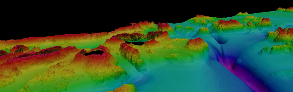
Multibeam Bathymetric Surveys
MULTIBEAM BATHYMETRIC SURVEY DATA PROVIDES RICH INFORMATION OF
THE UNDERWATER TOPOGRAPHY OF THE WORKSITE

Ollerhead & Associates Ltd. uses Multibeam echo sounders for accurate data acquisition, along with HYPACK and Civil 3D software to generate comprehensive final products.

Advantages to multibeam bathymetric surveys are:
- 100% Bottom Coverage
- Able to Survey a Wide Swath with More
- Rich Data Acquisition Allows for Accurate Infrastructure Delineation

Ollerhead & Associates Ltd. provides detailed depth measurement surveys, adaptable to multiple applications, such as:
- Under Water Pipe locating
- Bridge Buttress Mapping and Analysis
- Detailed Floor Mapping-Ice Scouring
- High Resolution Mapping of Wharf and Marines
- Pre-Dredging, Post-Dredging Volume Surveys and Cross-Sections